Memories of Iceland


Hofn is a small fishing town, with great seafood.
There was abit of overpacking as we find ourself rushing to Hofn without having much time to explore the lovely town.

6129483452_31e449c43a_z.jpg

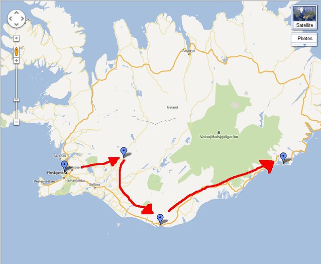
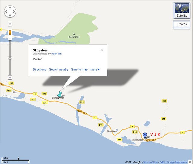
Our drive in a typical anticlockwise manner, our previous stop was Vik

6128885441_43a2bb33a5_z.jpg

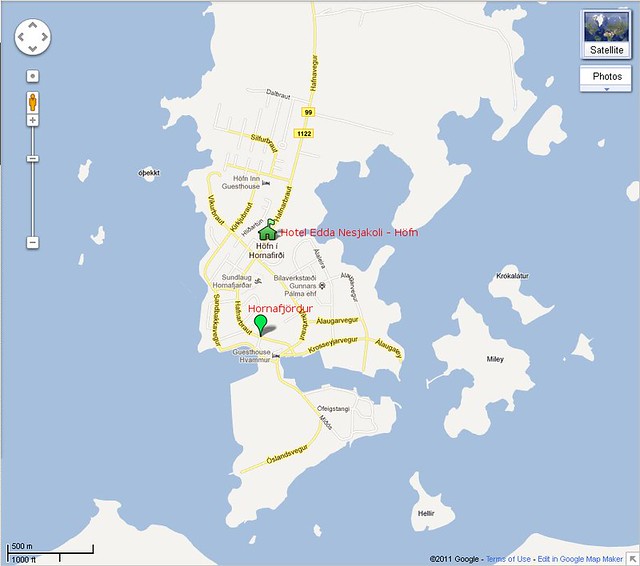
We stayed in Hotel Edda Nesjakoli, one of the popular Hotel Edda chains. Shared toilet, but pretty nice cosy small room.
Ours faced the field behind and had a great evening view of the mountains. We reached so late that it was past sundown, and the staff kindly provided us with whatever left over of dinner for us ( the scraps tasted fantastic! ) The hotel is actually a few kilometres before Hofn proper, and next to a pump station ( I think it was Orlis )

# 31

6127595548_956d2c766a_b.jpg


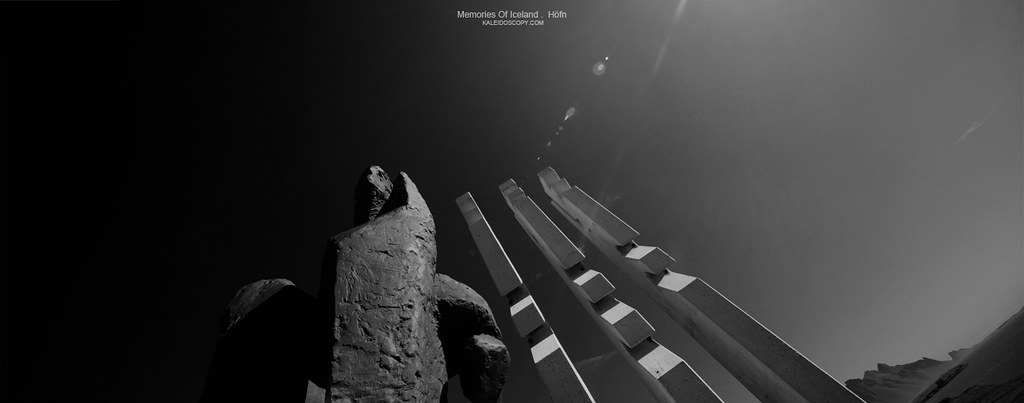
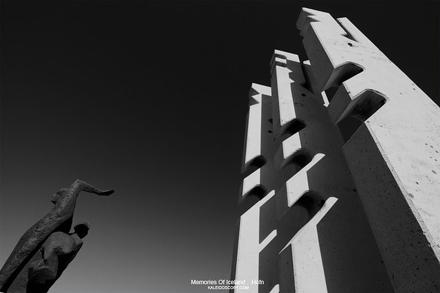
A simple 5 min JPG stitched -> B/W panorama of a certain statue in Hofn taken the next morning before we left. While I cannot locate the position, it was pretty obvious from the Hofn harbor, so if you are vising it will not be difficult to spot. The skies were extremely clear and blue that day, one of those days where a polariser will overdo things ( anyhow I cannot fit the lens on my bulbous lens .. ) Hofn has beautiful harbors in the evenings near sunset, which i missed unfortunately.
 

# 32

On how the above would have looked side on.

6127013571_4c861dbda6_z.jpg
 

Love the Skogafoss' shots. :thumbsup: Its amazing just to be there, isn't it ?

Next time I definitely want to drive on Route 1 all around Iceland and also visit Landmannalaugar.

Will pester you for tips... :bsmilie:
 

# 34

Seljalandsfoss. Taken off a reflection from a little lake created probably from the on going rain for the past 5 days straight.
Taken with an umbrella over me and my setup, you can see bits of rain drops over the water. 3 vertical jpgs stitched.

6140097267_30471aeb59_b.jpg


**
The same waterfall as posted in # 16

6093035901_1d89d5e77d_m.jpg
 

Love the Skogafoss' shots. :thumbsup: Its amazing just to be there, isn't it ?

Next time I definitely want to drive on Route 1 all around Iceland and also visit Landmannalaugar.

Will pester you for tips... :bsmilie:

Thanks asterixsg! Landmannalaugar is best visited when you can put aside like 3-4 days for a hike around or even longer.
With your style of travelling, it should not be a problem!

Ryan
 

L-O-V-E THIS!!!
are you going to do an interactive map of your trip too? :)

Thanks mate!

# 28

Evening while on the way back, a late evening reflection at Lake Langavatn in Snaefellsnes
6124053304_1d06175b97_z.jpg
 

Love this series! Love the T/S shots especially!
 

L-O-V-E THIS!!!
are you going to do an interactive map of your trip too? :)

Thanks EM. I am in the process of editing the previous posts and add more screen caps of google map for locality. I don't think the forum at this moment allows me to embed google map.

Love this series! Love the T/S shots especially!

Thanks! Watching your mirrorless space as well :)


Litlibær, Westfjords.
aka Little Farm *( Baer = farm in Icelandic )

A wooden turf house well preserved since it was first built in 1895 by the families of two friends, at one time 20 people stayed in this tiny little house ( the two bedrooms were really really small ). The old granny and her grandson made us the best waffles with coffee and tea. While granny stays about a kilometer away down the road, her grandson stayed at Selfoss ( southern Iceland ) and was helping his granny during his sch holidays ( mainly as a tourguide since she only speaks Icelandic ). Only 2 small tables in 2 cosy rooms for guests in the 1st level and a table outside the house, if there are many tourists one will have to queue.

6143020928_0248f5e782_z.jpg


( While from the map it seems the place is deep insular, actually it is just next to the coast along the coastal drive. It was one of those serendipitous finding as we drove along the westfjords, " hey interesting hut, lets have a look " that led to the tasty waffles breakfast.

# 35


Tilted shifted stitched pano, 17TSE, 3 jpg stitched.
6140864824_5e1d719647_b.jpg
 

Its been a while since I logged on to CS and even longer since I picked up my camera.

Came in to try my luck look for info on Iceland travel and was really excited to see that both Asterix and yourself have created threads on it.

Stunning pictures and wonderful tips so far, will definitely come back more often to check for more. :)
 

Last edited:
The Westfjords and Snaefellsnes are really beautiful! Pity I hadn't enough time to explore them in my last visit, would love to cover them if I return to Iceland next time.

Btw, are the roads in Westfjords paved or gravel?
 

Its been a while since I logged on to CS and even longer since I picked up my camera.

Came in to try my luck look for info on Iceland travel and was really excited to see that both Asterix and yourself have created threads on it.

Stunning pictures and wonderful tips so far, will definitely come back more often to check for more. :)

Thanks ahbian nice to see u back again and your kind comments !

Yes, got to love this...this is outstanding...great simplicity..

Gives a sense of calmness and tranquality...well done Ryan!

Thanks soulFLY. Tranquality wise your long exp works probably brought more of that to the forum than many one else.

The Westfjords and Snaefellsnes are really beautiful! Pity I hadn't enough time to explore them in my last visit, would love to cover them if I return to Iceland next time.

Btw, are the roads in Westfjords paved or gravel?

Hi BrownBoots, Westfjords are mostly paved. You'd find that many of the older maps including mine still not too updated with large stretches of unpaved roads. But I think we still clocked a good distance of gravel roads along Westfjords ( probably almost 100km ). IMHO the worst gravel stretch was to Breiðavík, which I thought was a tough drive since they also stinge somewhat on putting gunrails at many good sharp corners up the fjords. I think at one time my left side mirrors nearly scrapped a big local blue trucker on the mountain as he was descending hastily without much awareness to keep to his side ( gravel roads are narrow )

The path from Breiðavík to Látrabjarg is unpaved, with the road up mid Látrabjarg with much danger signages for falling rocks from the cliff. Most travelers quote this drive as the scariest along the mainroads of Westfjords. Especially in evenings where the glare reflection of sun and that from the reflected waters blind drivers.

# 36

Cape Ingólfshöfði

A privately owned black basaltic cape that is separated from the mainland via vast area of black sand, traversable by large farm tractors. We left Skatafell Nat Park early to reach the reception hut at Ingólfshöfði around 230pm. It is a short dirt path offshoot from the main highway ( pay attention to the signages! ) And after a bumpy ride you reach a small hut and an even smaller toilet hut.

We were warned that there was no puffin seen over the past few days, but we still took up the trip nonetheless. Ingólfshöfði has a large number of birds including the amusing Atlantic puffin. One way trip was around 45 minutes of ride. Remember that sandstorms can happen anytime, so bring something to cover the face. One thing to note is if one is bringing huge tele equipments for shooting, you will need reasonable fitness to follow the group ( the trip was mainly catered for sightseeing and a little history lesson but from the web it seems they do have separate trips for bird shooters ) Lugged my old tele up and was severely burdened, not much birds to shoot, wrong season! :confused:

6148368389_d486029ea6_z.jpg

DIY marking of the location on google map, thats the Cape, the entry to the info/booking counter is nearby :bsmilie:

6130270608_a34b2d0064_z.jpg

Note the tractor that was used to traverse the black sand planes at the background. A small sandstorm picked up at the distance as the unobstructed wind brings up the fine black sands easily. My face and nostrils were filled with the sand on the way back!

More here : http://www.oraefaferdir.is/fromcoasttomountains/Coast_Tour.html

Ryan
 

Ingólfshöfði with a view of Öræfajökull in the distance. After the slight rain came the storm clouds at a distance. I was the last marker of the entourage and they were preparing for the descent. You can see the sandstorm building up as a haze near the horizon.

# 37

The Great Skua
6130272794_0b58f19ab7_z.jpg


# 38
6130274430_4d1c2bbfea_z.jpg


Ryan
 

nice sets.. love them. i am now plannin to go iceland! may i ask, will my posb go card works there?
 

nice sets.. love them. i am now plannin to go iceland! may i ask, will my posb go card works there?

Hi thanks fozosix! I am not sure of the POSB Go Card. In their website they say they allow PIN purchase from Maestro merchants overseas, not sure how that works out. You might have to ring up POSB to ask if you can make overseas transaction with PIN ( just so remember we are not talking cash advancement overseas .. )

Ryan
 

Driving on F*** roads are a love and hate affair. ( F roads are followed by 3 digits, and these roads are off limits to non 4WD vehicles. Unpaved, they can be very slippery even when dry, or strewn with knuckle sized rocks or potholed ridden. I had a few opportunites to have my 4WD slide when doing cornering, not a pleasing experience when going out of control ) They may tempt you with short cuts to a certain destination and yet give one heck of a bumpy slow ride, dusty roads, and yet reward with some hidden vistas that the usual Ring road drivers do not see. Alot of F roads are closed off season so you might have to check before hand.

# 39
Along F939, a short morning break for us next to a small waterfall. We were glad the big tourist bus was in our direction of travel, as they stop by different sites for the tourists to stop by and walk abit ( and so did we )

6162171431_df9f53ea32_b.jpg


Here is a website with dynamic updates of icelandic road conditions that I find to be useful :
http://www.vegagerdin.is/english/road-conditions-and-weather/the-entire-country/island1e.html
 

Last edited:
And a documentary take of the start of a rocky path on the clearing next to F939 road. Taken probably 30 mins before we reached the stream in #39 . The cascading rays disappeared shortly after it was taken unfortunately.

# 40

6168841795_e71035ac86_b.jpg
 

Glaumbær

Beautiful turf houses built in the 18th century with wood with clay ( Turf houses in iceland converted to using concrete a little later ) We visited Glaumbær during the opening hours and managed to tour along with the huge truck loads of tourists, the interiors, which were connected by a tiny dark central walkway. Some claimed that they were mentioned in old Iceland sagas, and if true might date these houses to an even earlier time

More information here : http://www.skagafjordur.is/default.asp?cat_id=1065

6183254155_61d53e0591_z.jpg

Situated at the southern part of Iceland

6183179477_6c4d33a6f7_b.jpg

We checked in Hotel Varmahlíð ( along road 1 ), before heading northwards to Glumbaer in the early afternoon.
On the way back in the evening I grab a shot of the houses before sunset.

# 41

Tilted shift stitched panorama

6175462692_7fd2253f46_b.jpg
 

We visited Krafla area when we were in Mývatn. Lake Mývatn is a rather shallow lake in the midst of a region with much volcanic activity, and we stayed in the little Reykjahlíð town, in the wonderful Hotel Reykjahlíð that faces the lake. Hotel Reykjahlíð was a family run business, and we were pampered with great food. The chef's style of lobster was the best I have ever tasted ( though unfortunately we did not get a chance to meet him, his effervescent wife taking orders and serving was clueless how it was prepared )

We visited Krafla area, a short scenic drive from Lake Mývatn

Click : Google Map

6196232395_29c0b0b729_z.jpg


One of the thermal vents harvested for energy. Unfortunately did not bring any ear plugs and could not get any closer, they roar and tremble the grounds like the engine of a sonic jet. Stopped by the side of the road to grab a shot.

# 42.

A jpg stitch of 3. The bit of rainbow might be a complicated lens flare

6129907146_4e7526ecf6_b.jpg